A six day (June 1 to 6th, 2019) trip paddling the Escalante River in Utah, from the Hwy 12 bridge to the crack in the wall exit. Mark and Ben paddled hardshell kayaks. We had good timing to take advantage of the melt of the healthy 2018/2019 winter snowpack, though the cool spring delayed the peak melt. This navigable stretch is about 75 river miles, from Hwy 12 East of town at Calf Creek, to the Coyote Gulch hike out at Crack in the Wall. Though this was a good year to do the additional ~14 miles to Lake Powell, given the good river flows.
 |
| The start, taken by Julie from the Hwy 12 bridge. |
 |
| Julie hiked the first few miles, as fast as we could paddle. |
 |
| The depth is pretty low at the start and it is easy to hang up on a gravel bar, which are hard to see. |
 |
| So the start involves some scraping along. Boulder Creek comes in after 6 miles, which approximately doubles the river flow. Another picture taken by Julie. |
 |
| The river usually cuts a channel through willows, with cottonwoods on the side. |
 |
| These upper stretches of river in particular used to be choked with non-native russian olive trees overhanging the river, but teaming between conservation groups and federal management has successfully removed the majority of them, with substantial effort. Thank you Escalante River Watershed Partnership. |
 |
| Mark enjoying the increasing depth. |
 |
| The sandstone walls just get taller for the entire trip. |
 |
| The river bottom is pretty wide on the upper part of the river. |
 |
| This was the first portage, which was due to a fallen tree strainer hazard. We portaged three times, here, a logjamb after Fence Canyon, and the usual boulder jamb portage. |
 |
| At times the river is just sweeping turns in a corridor of green, despite the red rock southern Utah desert surroundings. |
 |
| A water gathering stop and hike at a side stream (Harris Wash). |
 |
| Looking back to the main river. |
 |
| A bigger hike at Choprock Canyon. |
 |
| This cottonwood has quite the grip on this rock! |
 |
| It was an exposed section of root, that looked more like a section of trunk. |
 |
| A mile or two up the north fork of Choprock Canyon. |
 |
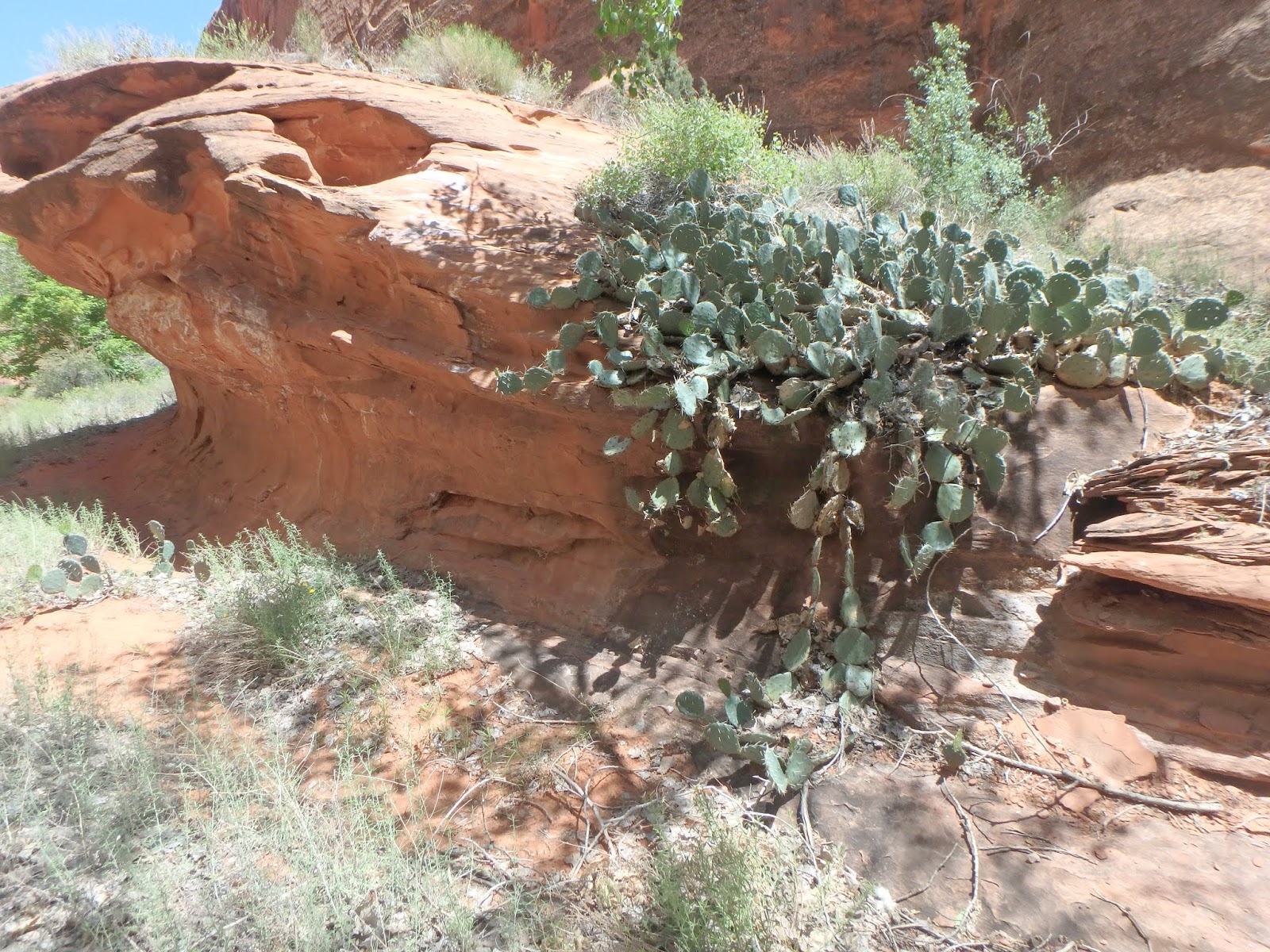
| A very healthy prickly pear in the south fork of Choprock Canyon. |
 |
| The walls are clean, tall, and steep in the Fence Canyon area, which is the easiest hiking access to the river bottom, popular with hikers to see the Golden Cathedral of Neon Canyon. We surprised some hikers that were not expecting boats to float by. |
 |
| Mark and I had been in this area in 2015, to complete a canyoneering descent of Neon Canyon. |
 |
| This is the mouth of Ringtail Canyon, the next one south of Neon. It quickly gets deep, narrow, and dark, and the water was rather deep this year, and a usual was quite cold. |
 |
| We had dramatic lighting in Ringtail. |
 |
| Mark, the Bringer of Fire. |
 |
| Mark being beamed back to the mother ship. |
 |
| Or to be sacrilegious, the assumption of Mark. |
 |
| Here is 25 mile Canyon joining in. We camped and filled up water here, which was the least desirable water of the trip, being rather silty. There were deposits of red silt, and currently green silt, which must depend on which upper canyon got rain last, since 25 mile canyon drains a huge area. |
 |
| The river starts to cut overhanging walls, as it begins to cut into the Chinle formation. |
 |
| The Chinle rock breaks into blocks of rock, some of which fall into the river and provide obstacles that make for more interesting paddling. |
 |
| Cooling off in the only water on another side hike. |
 |
| Mark liked this yellow Evening Primrose, when all the others encountered where white. |
 |
| A nap under a large cottonwood, that does a serpent impression. |
 |
| A mile loop hike in a Rincon, which is an abandoned bend in the river, after the river has cut a more direct path. This would be an oxbow lake, except the river keeps cutting more deeply down through its main channel, eventually leaving the rincons dry. A few are rather high up. |
 |
| The back end of the rincon, which was partially filled with sand. |
 |
| Our camp near Scorpion Gulch. |
 |
| Stopped to scout Scorpion Rapid. |
 |
| Which is a jamb of boulders with a ramping 4 foot drop (at this water level). |
 |
| Viewed from downstream boulders. |
Video of Mark effortlessly running a perfect line through Scorpion Rapid.
And video of Ben botching the tight entrance pivot, bumping his stern to stall the turn, flailing, and then bouncing off the center rock. A good comparison of an expert paddler, and an unskilled paddler.
 |
| The river is a bit faster and drops more on these last 25 miles. |
 |
| Another lunch nap. |
 |
| This rock tower is a good marker for the mandatory portage from the problem rock jamb. |
 |
| Precious shade. |
 |
Looking down at the boulder jamb choke point. It is quite narrow and most of the current volume is deep, not at the surface. |
 |
| A view from downstream. A small boat might squeeze through, but the undercut is right at face bashing level. |
 |
| The river canyon keeps getting deeper. |
 |
| More of the cracked blocks. |
 |
| Some stretches involved fun tight maneuvering in river rock gardens of large boulders. |
 |
| We were pondering what frequency flood deposited the woody debris on top of the large boulder, probably around 20 feet up. A 50 year flood? 100 year? 500 year? How long does it take to decompose in this environment? |
 |
| Another tower, perhaps the site of a future small rincon. |
 |
| The walls become a complex mix of slabs and overhangs. |
 |
| Not much room for foliage other than willows and non-native tamarisk. |
 |
| A huge undercut alcove. |
 |
| A bizarre formation for sandstone, very symmetrical. |
 |
| Looks like a ship's bow. |
 |
| The junction with Stevens Canyon. |
 |
| And the massive and impressive Stevens Arch. |
 |
| Hiking up Stevens Canyon. |
 |
| Stevens Arch from downstream. Supposedly planes have flown through it. |
 |
| It looms over the river from downstream. |
 |
| A river surrounded by rock. |
 |
| The start of the carry-out. Which begins right away with a crossing of a somewhat steep, sandy rock slab. |
 |
| Not super fun with heavy creek boats. There is a good reason that most people use packrafts on this river. |
 |
| Nearing the Crack in the Wall exit. |
 |
| Mark holding his throwbag, which is our tool to get the boats up the cliff. |
 |
| Up goes Mark's boat. |
 |
| Stevens Arch, and the Coyote Gulch confluence with the river are visible just above and to the right of the bow of the boat. |
 |
| This is the Crack in the Wall crack, which angles about 50 feet up the cliff. Easy to shuffle and scramble for an unburdened person, but it is too tight for even big packs, never mind kayaks. |
 |
| A view from the rim of the river canyon. |
 |
A final view on the hike back down to make a second trip for all our camping items, paddles, and pfds.
|
Thank you to Julie for picking us up at the takeout, sparing the need for an initial trip down Hole in the Rock road to stage a takeout vehicle.